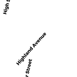
39 HIGHLAND AVE
Owner Information
CODNER PHILLIP A
39 HIGHLAND AVE
FALL RIVER, MA 02720


Property Details
39 HIGHLAND AVE is classified as a Single Family Residential (Colonial).
The primary structure on this property was built in 1861. There are 3,748ft2 of built area within this property. There is 3,748ft2 of residential/living space within this property. This property is listed as having 11 rooms.
39 HIGHLAND AVE is valued at $371,100. The land is valued at $97,300 and the structures are valued at $264,700. There is an additional valuation of $9,100 on this property.
This property is in Zone A-2. Confirm with local Zoning Board authorities to ensure there are no overlays or other easements on this property.
The most recent deed for 39 HIGHLAND AVE is recorded at the local registrar in Book 9381, Page 294. 39 HIGHLAND AVE was last sold on Friday, November 10, 2017 for $1.
Assessment data from fiscal year 2022.
Flood Data
According to the FEMA National Flood Hazard Layer, this property does not appear to be in a flood zone. It may also be in an area not yet reviewed. Nonetheless, confirm this information prior to taking any action.
To view the flood hazards around this property, create a FEMA "Firmette" Map of the area around 39 HIGHLAND AVE.
Broadband Internet Providers
| Provider | Type | Bandwidth (mbps) | |
|---|---|---|---|
| HughesNet | Satellite | 25 | 3 |
| GCI Communication Corp. | Satellite | 0 | 0 |
| Comcast | Cable | 1000 | 35 |
| VSAT Systems, LLC. | Satellite | 2 | 1 |
| Verizon New England Inc. | DSL | 15 | 1 |
| Crown Castle Fiber | Fiber | 0 | 0 |
| Viasat Inc | Satellite | 100 | 3 |
Broadband service provider data from December 2020.
Adjacent Properties
- 19 HIGHLAND AVE
Apartments with Four to Eight Units owned by CASHMAN DENNIS - 316 WINTER ST
Single Family Residential owned by MCGLYNN ROBERT J - 330 WINTER ST
Two-Family Residential owned by MATTOS BRANDON C - 55 HIGHLAND AVE
Mixed Use (Primarily Residential, some Commercial) owned by TAUNTON THREE PROPERTIES LLC